01 / Hydrology
Hydrology
Routine monitoring on rivers, lakes, reservoirs, and hydraulic sections.
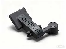
SF200 is a lightweight UAV radar payload that measures surface velocity and stage over sections you cannot wade or bridge. It focuses on V+stage payload, UAV non-contact, Flight-data fusion, ready to connect with sounding, navigation, or monitoring workflows. Typical uses include Hydrology, Harbor and marine, Engineering.
SF200 is a lightweight UAV radar payload that measures surface velocity and stage over sections you cannot wade or bridge.
Radar captures surface velocity and stage (air gap) in one hover or route.
No shore bracket—fly to hazardous sections and measure from above.
Links with flight/flow software to log waypoints, attitude, and results.
Designed for multirotor mounts with quick change for emergency teams.
SF200 follows clear collect–process–output steps matched to this product type.
Pick section waypoints and hover height on the map.
Aircraft arrives and stabilizes over the point.
Capture velocity and stage air-gap together.
Flow results return via video/data link to the ground station.
Key figures and field capabilities for SF200, for quick selection.
From routine monitoring to complex engineering sites, choose deployment and data links around the task.
Routine monitoring on rivers, lakes, reservoirs, and hydraulic sections.
Support harbor, channel, marine survey, and vessel engineering work.
Support dredging, placement, pipeline, mapping, and construction checks.
Connect stable outputs to shore stations or remote data platforms.
Key parameters for SF200 (from the product page and sales description).
| Model | SF200 |
| Payload | Current + stage |
| Mode | Track / hover |
| Key points | Drone-mounted radar measuring surface velocity and water level together. Key figures: UAV payload, radar velocity + stage, lightweight, route gauging. Typical use: Hydrology; Harbor and marine; Engineering; Long-term monitoring. |
| Applications | Hydrology; Harbor and marine; Engineering; Long-term monitoring |