
For hydrology and water-affairs informatization, South Marine draws on group water-industry solution materials covering rainfall/water monitoring, dam safety monitoring, water-resources survey, Beidou spatial sensing, full-space twin modeling and a digital-twin platform—supporting digital-twin river basins, water networks and hydraulic works, including forecast, warning, rehearsal and contingency planning (the “Four Pres”).
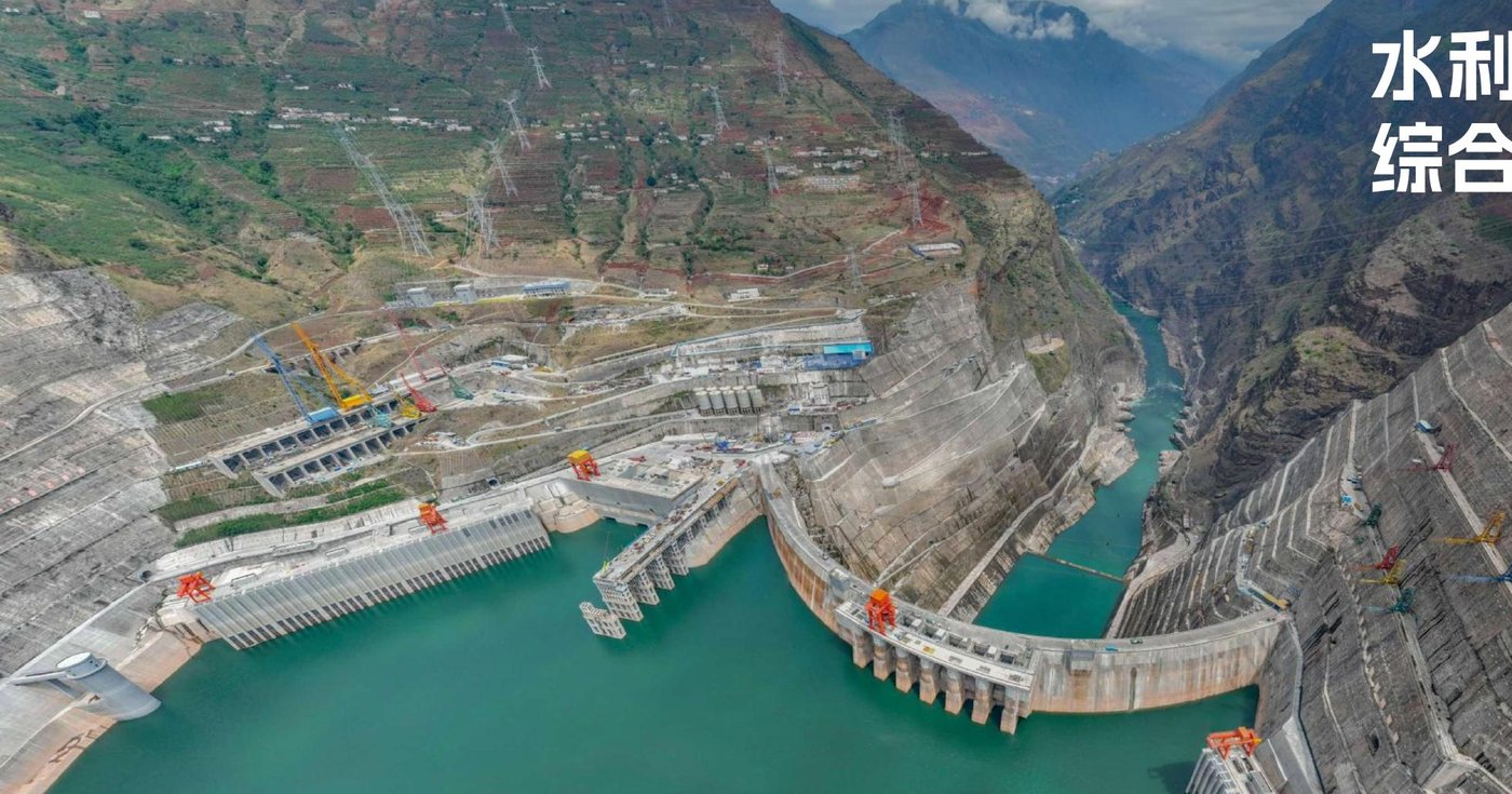
Scene from solution materials
Rainfall–runoff and dam safety monitoring
The rainfall/water and dam-safety package combines dam-body safety monitoring with rainfall/water reporting. Front-end Beidou telemetry and multi-source sensors collect water level, rainfall and deformation data, backhauled via fiber, 4G/5G, Beidou short message and LoRa into a monitoring cloud for sensing, inspection, analysis, safety management and emergency warning.
Rainfall/water side can include telemetry terminals, tipping-bucket rain gauges, radar/bubble/float level gauges and video sensing; dam safety side can include GNSS units, surveying robots, slope-deformation radar, piezometers, weir gauges and tilt monitoring for continuous seepage/pressure and surface-displacement monitoring with visualized management and graded alerts.
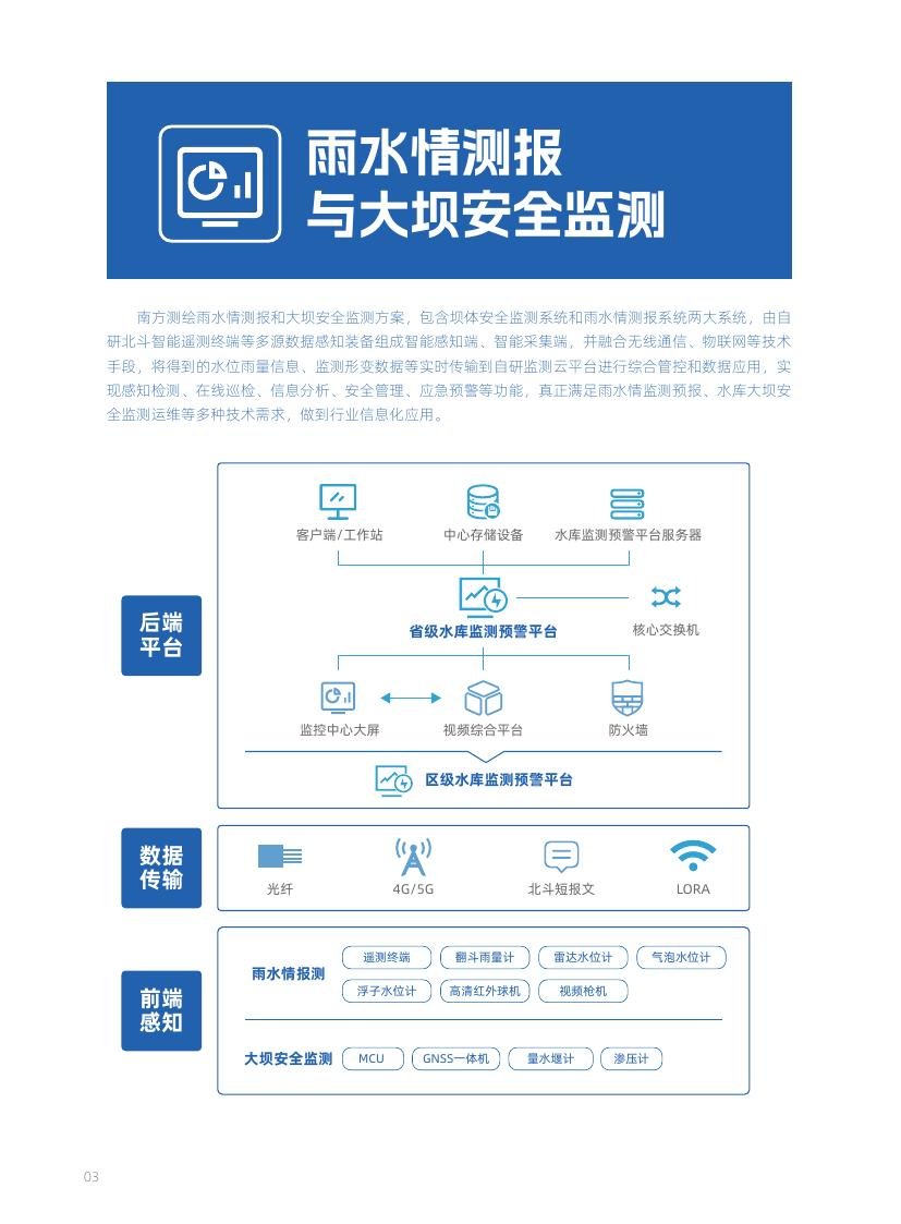
Architecture diagram from solution materials
Water-resources survey and water-affairs IT
Water-resources baseline survey covers water-body extent, storage, quantity, quality, annual change and thematic evaluation. Soft/hardware combining remote sensing, reality mesh, IoT, imagery and processing supports data capture through deliverables such as databases, tables, thematic maps and reports, and can connect to browse/query, management and O&M platforms.
For hydrometry and bathymetry, USVs with ADCP or single/multi-beam sounders, UAV flow measurement and airborne LiDAR can be combined for river discharge tests and reservoir topography/capacity work—improving efficiency and reducing on-water risk. Water informatization can link IoT sensing, data centers and business apps for supply, drainage, flood control and water saving.
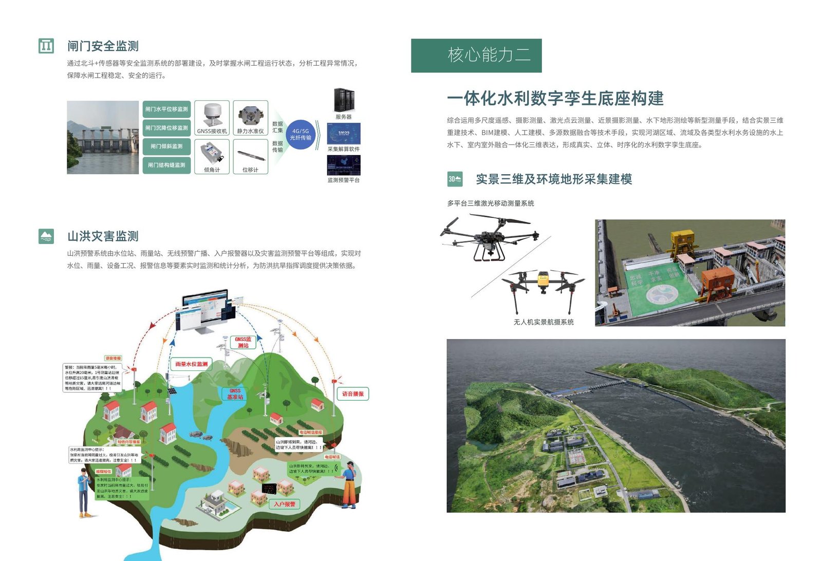
Sluice/torrent monitoring and integrated twin-base diagram (solution materials)
Beidou sensing and digital-twin platform
The water digital-twin solution centers on Beidou spatial sensing, full-space twin modeling and a twin platform, fusing spatio-temporal IT with water and hydrology businesses. Sensing covers rainfall, flow, level, quality, displacement, video, remote sensing, radar and satellite inputs across reservoirs, dams, rivers/lakes, irrigation districts, channels and urban waterlogging in a cloud–network–terminal stack.
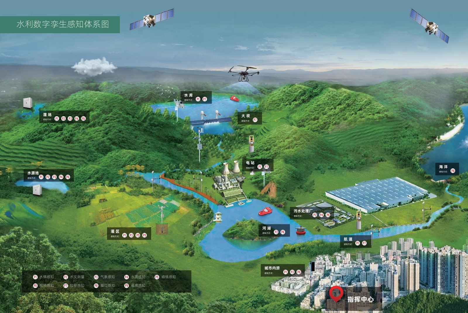
Perception-system diagram from solution materials
The integrated twin base uses multi-scale remote sensing, photogrammetry, laser point clouds, close-range photography and bathymetry with reality mesh, BIM and multi-source fusion for above/under-water and indoor/outdoor 3D expression of rivers and facilities—forming a realistic, stereo, time-sequenced digital base managed on the twin platform for rapid scene build and business integration.
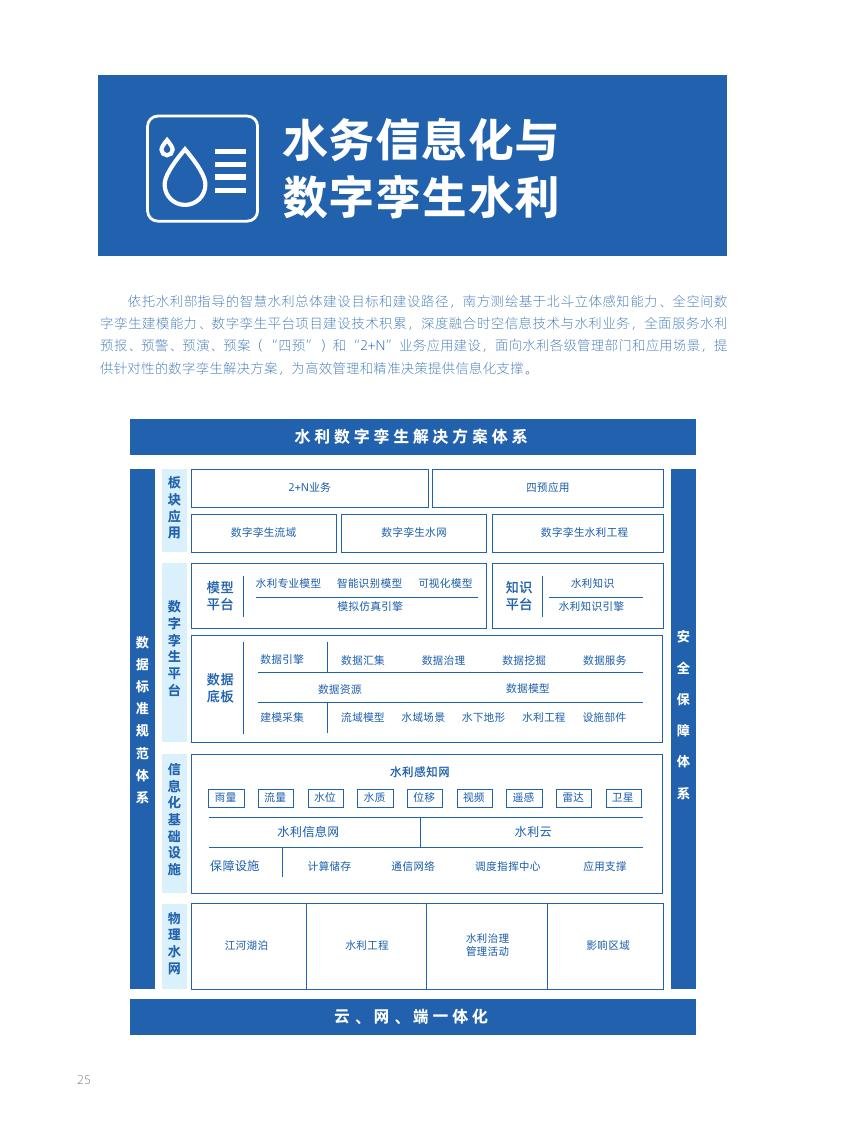
Solution architecture from solution materials
Applications cover digital-twin basins, water networks and hydraulic works for “2+N” businesses and the Four Pres: forecast from hydro-meteorological data, warning by risk level, rehearsal of dispatch schemes, and contingency plans combining experience with rehearsal results—supporting flood dispatch, water allocation and project O&M.
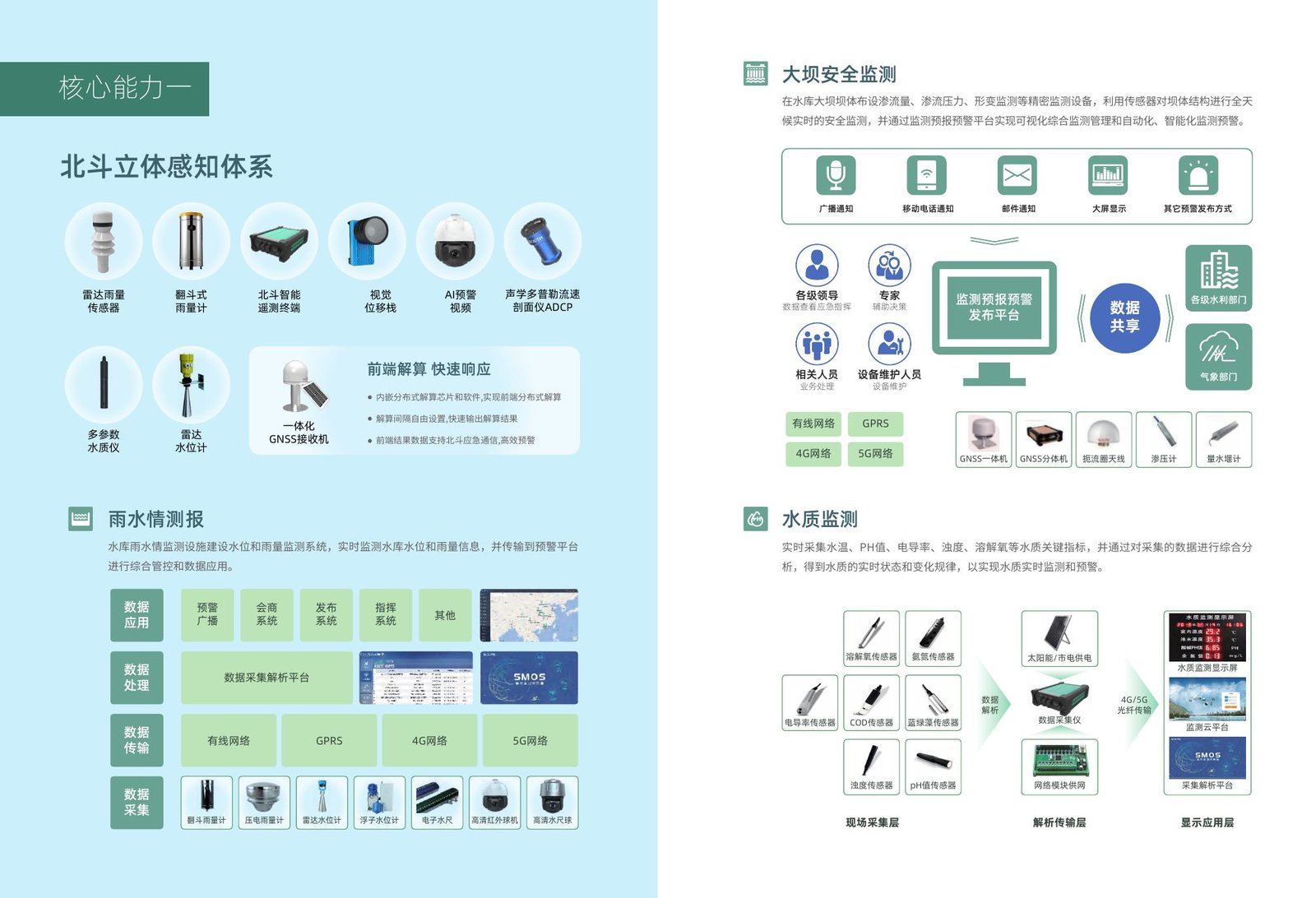
Beidou sensing with rainfall/water, dam and water-quality monitoring (solution materials)
Flood/drought defense and emergency support
Prevention stresses “pre-”, emergency response stresses “fast”. Using rainfall/water, works status, models and knowledge engines, the solution supports warning and dispatch for drought, ice flood and flood; mountain-torrent warning can combine level/rain stations, wireless broadcast and household alarms for real-time monitoring and statistics.
Emergency support can deploy airborne LiDAR, USVs, slope radar, reality-stakeout positioning and handheld 3D lasers to quickly produce oblique 3D models, orthophotos and bathymetry for hazard assessment and rescue planning.
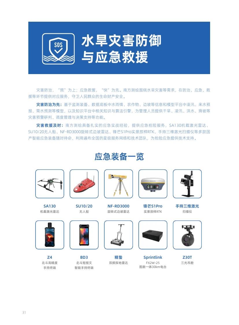
Defense and emergency capability diagram (solution materials)
Capability highlights and scenarios
- Rainfall/water monitoring: multi-source level, rainfall and video sensing into a warning platform
- Dam/sluice safety: continuous displacement, seepage/pressure and tilt monitoring with graded alerts
- Water-resources survey: soft/hardware support for extent, storage, quality and thematic evaluation
- Hydrometry and bathymetry: USV ADCP/multi-beam and UAV flow measurement combinations
- Beidou sensing + full-space twin modeling + twin platform for basins / networks / works
- Four-Pre apps: forecast, warning, rehearsal and contingency planning for flood and water-resources decisions
- Flood/drought defense and emergency survey: torrent monitoring and rapid hazard mapping products
Based on group brochures “Full-process Water Conservancy Solution” and “Water Conservancy Digital Twin Solution” for the South Marine website; configuration and scope per contract.